| Pages:
1
..
6
7
8
9
10 |
David K
Honored Nomad

Posts: 64545
Registered: 8-30-2002
Location: San Diego County
Member Is Offline
Mood: Have Baja Fever
|
|
Quote: Originally posted by mtgoat666  | | Quote: Originally posted by David K | Not that close... closer to an hour.
I guess I have not tried to see them is because of the shear size of the university, where to park, and not knowing protocol. Neal Johns (R.I.P) and I
were going to go see them at one time... then time won.
My step-son, Josh may be going there soon. His sister graduated from it a few years ago... I could ask them.
You are right to ask me, goat. |
Public university libraries are generally open for all. UCSD libraries are there for you.
Historical manuscripts/collections are often only viewable in certain rooms, due to being fragile. You normally just call or email to tell them what
you want to see, and book an appointment.
Parking on campus is easy, just pay the fee. The trolley and busses also serve campus.
The UCSD collection ae mostly listed on line, just call or email the listed contacts to ask how to access...
https://library.ucsd.edu/research-and-collections/special-co...
here is page to submit request for gullick maps
https://library.ucsd.edu/speccoll/findingaids/mss0091.html#a...
[Edited on 4-29-2024 by mtgoat666] |
Thank you... I have seen this before. I guess the question I would have, with so many boxes to request, and not knowing what exactly is in the boxes,
how many can be checked? Can I make copies or take photos of what I see? Am I the only one here interested in this?
|
|
|
Lance S.
Nomad
Posts: 163
Registered: 2-16-2021
Member Is Offline
|
|
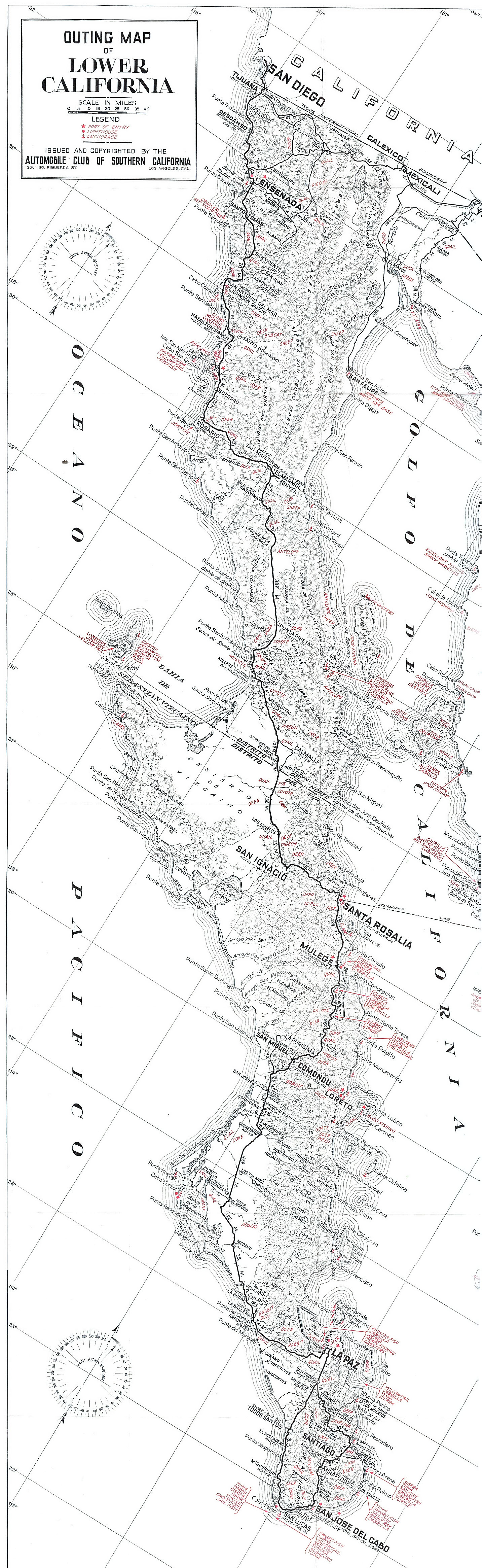
"This road is a part of a road which was intended to make wagon travel possible throughout the length or the peninsula. It has been built northward
from Calmallí, via Rosarito and San Andros (Rosarito quadrangle, pl. 60), and ends at Leon Grande. It is not likely that the northern extension of
this road will be built for many years, as there are few ranches in the region and the need for a road is not very great."
Is the plan for the wagon road what we are seeing on this 1946 map? It would be consistent with both the 1922 geology report and North's 1905
description of the 'main trail".
https://octopup.org/img/media/maps/baja/1946--Baja-Californi...
[Edited on 4-29-2024 by Lance S.]
[Edited on 4-29-2024 by Lance S.]
|
|
|
mtgoat666
Select Nomad
Posts: 17429
Registered: 9-16-2006
Location: San Diego
Member Is Offline
Mood: Hot n spicy
|
|
| Quote: Originally posted by David K | | Quote: Originally posted by mtgoat666 | | Quote: Originally posted by David K | Not that close... closer to an hour.
I guess I have not tried to see them is because of the shear size of the university, where to park, and not knowing protocol. Neal Johns (R.I.P) and I
were going to go see them at one time... then time won.
My step-son, Josh may be going there soon. His sister graduated from it a few years ago... I could ask them.
You are right to ask me, goat. |
Public university libraries are generally open for all. UCSD libraries are there for you.
Historical manuscripts/collections are often only viewable in certain rooms, due to being fragile. You normally just call or email to tell them what
you want to see, and book an appointment.
Parking on campus is easy, just pay the fee. The trolley and busses also serve campus.
The UCSD collection ae mostly listed on line, just call or email the listed contacts to ask how to access...
https://library.ucsd.edu/research-and-collections/special-co...
here is page to submit request for gullick maps
https://library.ucsd.edu/speccoll/findingaids/mss0091.html#a...
[Edited on 4-29-2024 by mtgoat666] |
Thank you... I have seen this before. I guess the question I would have, with so many boxes to request, and not knowing what exactly is in the boxes,
how many can be checked? Can I make copies or take photos of what I see? Am I the only one here interested in this? |
If it was me, I would check all the boxes and see what's in 'em.
If you got Qs about the library, then call or visit the librarian!
[Edited on 4-29-2024 by mtgoat666]
Woke!
“...ask not what your country can do for you – ask what you can do for your country.” “My fellow citizens of the world: ask not what America
will do for you, but what together we can do for the freedom of man.”
Prefered gender pronoun: the royal we
|
|
|
Lance S.
Nomad
Posts: 163
Registered: 2-16-2021
Member Is Offline
|
|
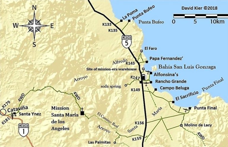
A rough breakdown of what appears on the 1946 map.

|
|
|
4x4abc
Ultra Nomad
Posts: 4202
Registered: 4-24-2009
Location: La Paz, BCS
Member Is Offline
Mood: happy - always
|
|
can anyone confirm the location of Pozo Salorio ?
Harald Pietschmann
|
|
|
David K
Honored Nomad
Posts: 64545
Registered: 8-30-2002
Location: San Diego County
Member Is Offline
Mood: Have Baja Fever
|
|
| Quote: Originally posted by Lance S. | "This road is a part of a road which was intended to make wagon travel possible throughout the length or the peninsula. It has been built northward
from Calmallí, via Rosarito and San Andros (Rosarito quadrangle, pl. 60), and ends at Leon Grande. It is not likely that the northern extension of
this road will be built for many years, as there are few ranches in the region and the need for a road is not very great."
Is the plan for the wagon road what we are seeing on this 1946 map? It would be consistent with both the 1922 geology report and North's 1905
description of the 'main trail".
https://octopup.org/img/media/maps/baja/1946--Baja-Californi...
[Edited on 4-29-2024 by Lance S.]
[Edited on 4-29-2024 by Lance S.] |
It sure seems so!
However, the map year is simply a printing date as the 'modern' road from San Agustin/El Mármol jcn. to Punta Prieta was in before 1930...
Here is the government's new road map to Mulegé, of Feb. 1927 (I suspect with AAA help): https://octopup.org/img/media/maps/baja/1927--Plano-de-los-C...
AAA Peninsula map of 1930: https://octopup.org/img/media/maps/baja/1930--Baja-Californi...
See all the maps in my VivaBaja collection: https://vivabaja.com/maps/
|
|
|
Lance S.
Nomad
Posts: 163
Registered: 2-16-2021
Member Is Offline
|
|
The lack of any mention of Las Arrastras is interesting.
|
|
|
David K
Honored Nomad
Posts: 64545
Registered: 8-30-2002
Location: San Diego County
Member Is Offline
Mood: Have Baja Fever
|
|
Didn't we conclude (in the past) it was Las Palmitas... about 10 miles southwest of Gonzaga Bay? 29.6728, -114.4721 ?
|
|
|
Lance S.
Nomad
Posts: 163
Registered: 2-16-2021
Member Is Offline
|
|
| Quote: Originally posted by David K |
Didn't we conclude (in the past) it was Las Palmitas... about 10 miles southwest of Gonzaga Bay? 29.6728, -114.4721 ? |
It was after crossing the divide between Rinconada and La Turquesa according to old maps. The 1922 report sounds like it was near La Turquesa but it
is not clear.
[Edited on 4-29-2024 by Lance S.]
|
|
|
David K
Honored Nomad
Posts: 64545
Registered: 8-30-2002
Location: San Diego County
Member Is Offline
Mood: Have Baja Fever
|
|
Las Palmitas is the next canyon north of La Turquesa. It is on El Camino Real, also.

[Edited on 4-30-2024 by David K]
|
|
|
4x4abc
Ultra Nomad
Posts: 4202
Registered: 4-24-2009
Location: La Paz, BCS
Member Is Offline
Mood: happy - always
|
|
just to throw a little wrench into the game:

Harald Pietschmann
|
|
|
4x4abc
Ultra Nomad
Posts: 4202
Registered: 4-24-2009
Location: La Paz, BCS
Member Is Offline
Mood: happy - always
|
|
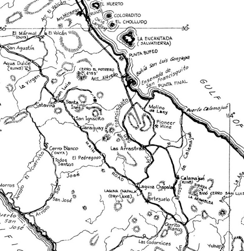
so, here is what we have
in the northern part of the image we have a location called La Rinconada
a tough section of a trail (been working on tracing it) from Jaraguay to Las Palmitas
Las Palmitas could have been Pozo Saloro or Aguae Calam
in the southern part we have Arroyo La Rinconada flowing from Cerro Pedregoso SW
La Turquesa road runs parallel for a little bit
to the east of it is Arroyo La Turquesa with a water source near the bottom
which could have been named Pozo Saloro or Aguae Calam
Las Arrastras in the right hand corner

Harald Pietschmann
|
|
|
David K
Honored Nomad
Posts: 64545
Registered: 8-30-2002
Location: San Diego County
Member Is Offline
Mood: Have Baja Fever
|
|
I have been to Las Palmitas a couple of times (1999-2003) and it always seemed to be a dead end, box canyon. The El Camino Real reached it from the
east and left it going north, as the auto road now does.
This photo of me hiking uphill from Las Palmitas (palms in background) was taken by BajaMur (RIP). I recall just boulders beyond this point...? Maybe
I am on the trail that Harald shows?

Here is my son at the water in La Turquesa Canyon, 2002:
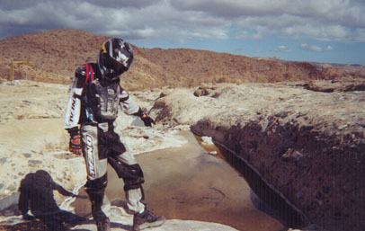
29°33.73′, -114°23.93′
More photos of the water in La Turquesa Canyon taken by Wayno (B&BBait) at https://vivabaja.com/wayno/


Water is everywhere... if you know where to look!
|
|
|
4x4abc
Ultra Nomad
Posts: 4202
Registered: 4-24-2009
Location: La Paz, BCS
Member Is Offline
Mood: happy - always
|
|
here are the traces I have so far

Harald Pietschmann
|
|
|
Lance S.
Nomad
Posts: 163
Registered: 2-16-2021
Member Is Offline
|
|
Jaraguay used to have lots of palms. Just like Agua Dulce they are gone now. Learned something new today!
14 Kilometers from Jaraguay puts you right at La Rinconada on Km 213 of the highway.
Isn't the well at Las Arrastras drilled through solid granite?
[Edited on 4-30-2024 by Lance S.]
|
|
|
David K
Honored Nomad
Posts: 64545
Registered: 8-30-2002
Location: San Diego County
Member Is Offline
Mood: Have Baja Fever
|
|
Jaraguay by Howard Gulick
The 1962-67 Lower California Guidebook:
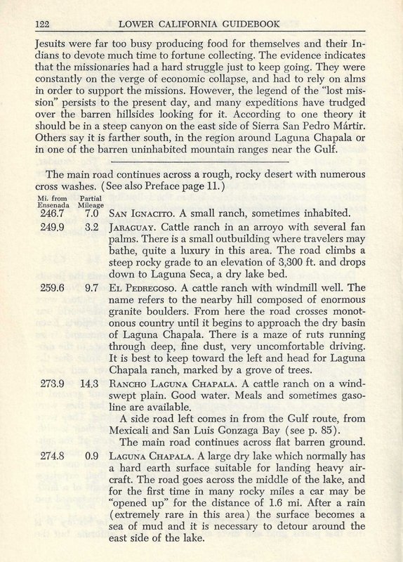
------------------------------------------------------------------------------------------------------------------------------------------------------
---------
Rancho Jaraguay in May 1957:
Remains (between Km. 196-197, east of highway on the Old Road): 29° 37.653'N, 114° 36.344'W
[Edited on 4-30-2024 by David K]
|
|
|
bajaric
Senior Nomad
Posts: 612
Registered: 2-2-2015
Member Is Offline
|
|
Thanks Lance, for finding and providing a little more info on Leon Grande from Beal:
"the well of Leon Grande (42 kms.).
The latter is a well about 90 foot deep and has a windlass, cable, and a large iron bucket."
So, a well was dug there at some point!
That would be fun to go out to the end of that road west of Parador Punta Prieta and try and find Leon Grande. The wooden structures associated with
these old camps from 1900-1920 have usually vanished. There is, however, usually one thing that remains, their trash! If a place was inhabited for
any significant period of time you usually can find trash dumps that contain old tin cans, glass bottles, and fragments of crockery. If there were
workers there long enough to dig a well and build a wagon trail I bet somewhere nearby one could find an old trash dump.
On the road a couple miles west of Parador Punta Prieta there is a big trash dump but it is modern trash, a whole bunch of those fat brown beer
bottles that had the opener recessed into the bottom of the bottle. I can't remember what kind of beer that was and when those were in use? That is
a neat area, lots of cardon, super remote the farther west that you go, has not changed much in the last 100 years.
[Edited on 5-1-2024 by bajaric]
|
|
|
4x4abc
Ultra Nomad
Posts: 4202
Registered: 4-24-2009
Location: La Paz, BCS
Member Is Offline
Mood: happy - always
|
|
trying to locate the remnants of rancho Pedregoso
any leads?
Harald Pietschmann
|
|
|
David K
Honored Nomad
Posts: 64545
Registered: 8-30-2002
Location: San Diego County
Member Is Offline
Mood: Have Baja Fever
|
|
Unfortunately, no Gulick photos of the ranch. Only one of the boulder hill and one of a mule cart... from 1957:
Cliff Cross, in his 1970 Baja Guide shows us what remains of Rancho El Pedregoso:

The Old Road passed the boulder hill on the west side, whereas Hwy. 1 was built to the east of the famous landmark hill.
Harry Crosby has several photos of the boulder hill.
Harald, I looked without success, but maybe you can find that concrete water trough or ranch remains?
|
|
|
4x4abc
Ultra Nomad
Posts: 4202
Registered: 4-24-2009
Location: La Paz, BCS
Member Is Offline
Mood: happy - always
|
|
looking at the 1962 Gulick map we have some strong pointers
Arroyo san Jose - upper section not shown on today's topos
Arroyo San Jose (flowing down from Cerro Pedregoso - the real big one) runs past Rancho El Pedregoso
with a distinct curve
judging by how the ground looks like, I think it was here:
29°31'41.56"N, 114°31'7.61"W
no clear signs of the trough - but a faint indication


Harald Pietschmann
|
|
|
| Pages:
1
..
6
7
8
9
10 |


