| Pages:
1
2 |
David K
Honored Nomad

Posts: 64547
Registered: 8-30-2002
Location: San Diego County
Member Is Offline
Mood: Have Baja Fever
|
|
1941 Road Map + Road Log now on Viva Baja Maps and here...
Detailed Map viewing in the link below...
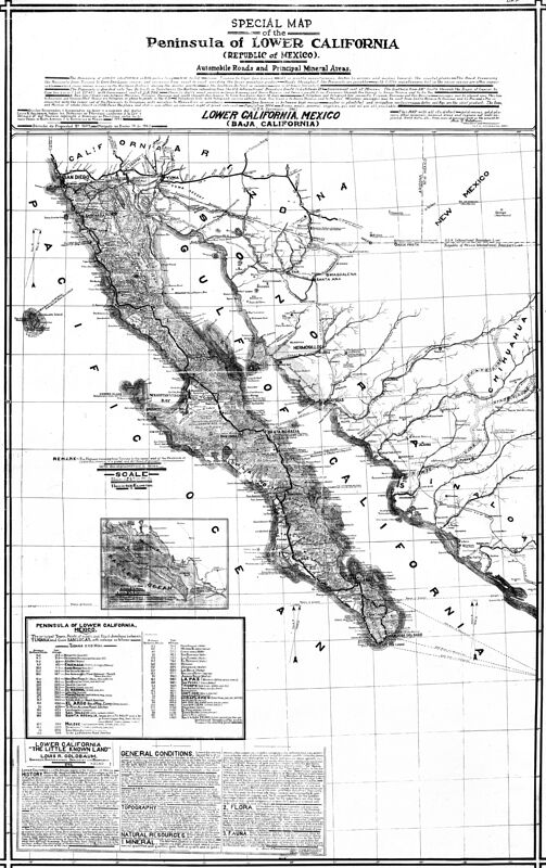
Click again for zoom in detail: https://octopup.org/img/media/maps/baja/1941--Special-Map-of...
|
|
|
AKgringo
Elite Nomad
Posts: 5853
Registered: 9-20-2014
Location: Anchorage, AK (no mas!)
Member Is Offline
Mood: Retireded
|
|
It makes me want to join Peabody and Sherman in the "way back" machine and go for a drive!
If you are not living on the edge, you are taking up too much space!
"Could do better if he tried!" Report card comments from most of my grade school teachers. Sadly, still true!
|
|
|
PaulW
Ultra Nomad
Posts: 3021
Registered: 5-21-2013
Member Is Offline
|
|
It would be a good read with a scan of just the text.
Is that possible?
|
|
|
David K
Honored Nomad
Posts: 64547
Registered: 8-30-2002
Location: San Diego County
Member Is Offline
Mood: Have Baja Fever
|
|
I did the scans, 21 were used to produce this, and then 'geoffff' has the software that stitches the maps together.
I hope you and Paul are looking at the 1941 map linked on www.VivaBaja.com/maps and not trying to see details on the map's image above (which is lower resolution for Nomad posting).
On my site, with the übber-high res image, you can read everything that is clear on the original copy-poster map that I have. Yes, there are some
faded strips on the original, if that is the area of question. The map was a gift from a Nomad 'BillB' about 19 years ago... The maps parts were
originally shared by Neal Johns, I believe? I had part of it on my oldest web page, of the area around the (non-existant) Mission Dolores del Norte,
which the Auto Club used to include, as well. It is pretty clear this map shares some common things with the 1930s Auto Club map, i.e. things were
copied from it.
I am glad you are enjoying this... Merry Christmas!
|
|
|
David K
Honored Nomad
Posts: 64547
Registered: 8-30-2002
Location: San Diego County
Member Is Offline
Mood: Have Baja Fever
|
|
First go to the 1941 map at www.vivabaja.com/maps and click on it twice, or use your fingers if on a phone, to zoom in super-close.
There is text all around the map... If you need a scan of just the road log, for example, I could do that for you, Paul. Do look at the link on my
site first as that should work for reading anything on the map.
Heading out for the family Christmas gift party... got 5 grandkids to see from four homes, all at one of the homes this morning! HoHoHo
|
|
|
bajaric
Senior Nomad
Posts: 612
Registered: 2-2-2015
Member Is Offline
|
|
Wow, another map drawn by Goldbaum! Upgraded from his 1918 map published in 1925, per vivabaja.com -- He switched from Spanish to English, probably
to market it to Americans.
He got the location of El Arco wrong, putting it north of Pozo Aleman, probably copied from the 1930's AAA maps that made the same mistake. Also
shows the mysterious Leon Grande, a water hole along an early north / south route shown on earlier maps but which by the 1930's had been bypassed by a
newer road that followed the approximate route of today's Hwy 1.
Goldbaum was active in the mining business in northern Baja for several decades up to the 1930's but appears by the time he drew this map in 1941 he
lived on South Boyle Ave in Los Angeles. He was probably getting along in years by then.
[Edited on 12-17-2022 by bajaric]
|
|
|
David K
Honored Nomad
Posts: 64547
Registered: 8-30-2002
Location: San Diego County
Member Is Offline
Mood: Have Baja Fever
|
|
Octopup is geoffff's site, it is my scans stitched together. Same with all the other maps. He makes three levels of zoom for size, and detail viewing.
On my maps page, is the highest level of zoom for detailed viewing. A lower level is shown here.
In addition to to stitching my scans, he also enhances them if needed for best possible viewing.
Ric, yes there are many errors perhaps copied from older maps. I think this Goldbaum is the son of the one who made the 1919/1925 map? Different first
names was my clue.
|
|
|
bajaric
Senior Nomad
Posts: 612
Registered: 2-2-2015
Member Is Offline
|
|
By George you are right! Must have been the son, Lous Goldbaum, maybe with input from dad. The drawing style is very similar to the senior
Goldbaum's map (David Goldbaum).
When I click on the octopup link a small image of map appears. Hovering the mouse curser over the map shows a little magnifying glass.
With one right click the enlarged version (slowly) opens. It is a big file.
|
|
|
David K
Honored Nomad
Posts: 64547
Registered: 8-30-2002
Location: San Diego County
Member Is Offline
Mood: Have Baja Fever
|
|
Correct.
On my PC the second click makes the map full size/ zoom. On my phone, spreading my fingers apart on the map zooms way in.
|
|
|
geoffff
Senior Nomad
Posts: 644
Registered: 1-15-2009
Member Is Offline
|
|
Quote: Originally posted by lencho  | | I assume you know all about scanning and image processing, but does the print on your paper maps, look like this under magnification?
|
Hi lencho, David does the scanning and I do the image stitching and contrast improvements for these maps.
It's funny, I also just did the same thing you did here yesterday -- zoomed in to stare at that ugly JPEG artifacting. It was noticeable enough for me
to want to make sure it wasn't my fault -- yes, the artifacting is there in the original scans I got from David, so I believe it is just that David's
scanner software is set to a "medium" quality JPEG save option (rather than "high" quality).
(Though I don't know exactly how you got the coloring and white halo around effect the text in the image you show. This is what I see for this same
region...)

The other weird thing about this map is that the paper map that David has seems to have been created using some kind of photocopy / Xerox method. It
is a photocopy of the original 1941 map. Therefore it has no grays -- everything is pegged to either full black or full white.
|
|
|
geoffff
Senior Nomad
Posts: 644
Registered: 1-15-2009
Member Is Offline
|
|
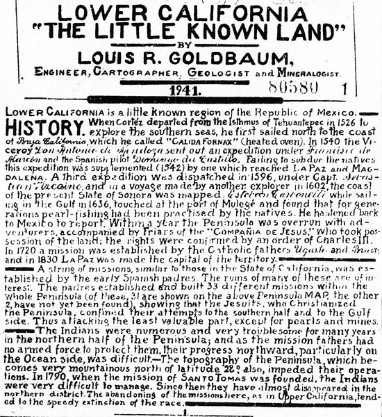
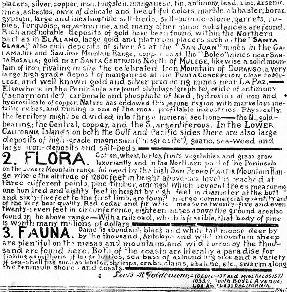
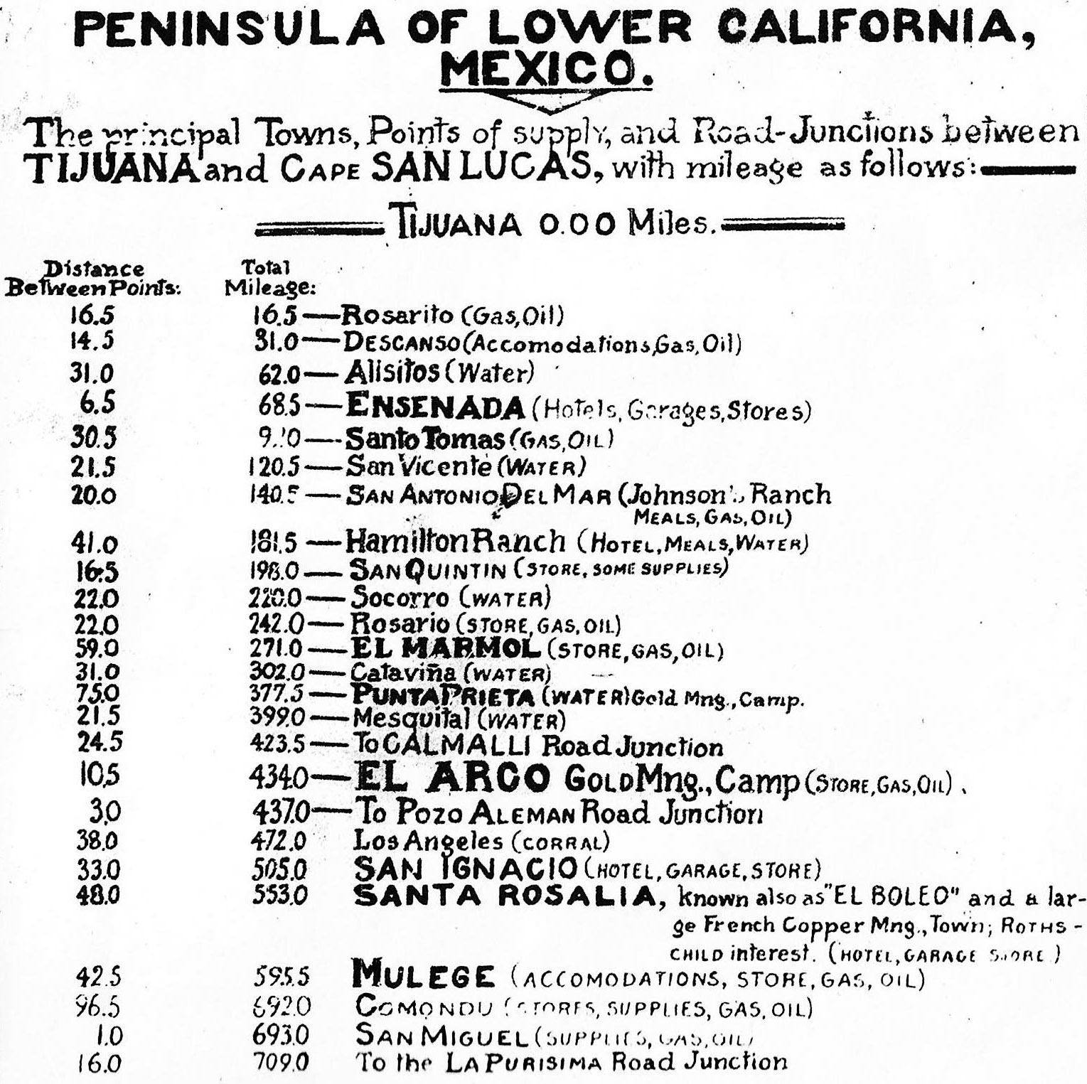
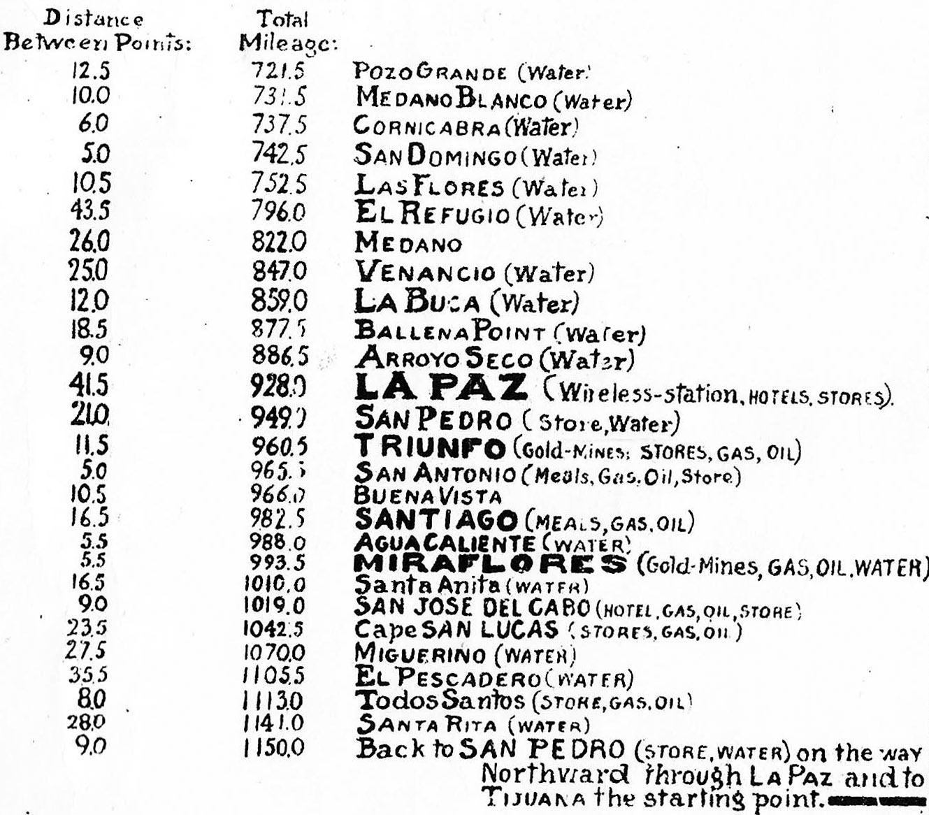
I was also thinking that would be fun! Here you go.... You can click on these images below to open/expand and then zoom in.


-- Geoff
|
|
|
geoffff
Senior Nomad
Posts: 644
Registered: 1-15-2009
Member Is Offline
|
|
| Quote: Originally posted by lencho | | In my opinion, scans of line-and-point graphics like that one shouldn't normally be handled as a jpg at all, at any point in the process, period, even
at the highest quality; [...] David, for future work you do with Geoff, see if you can't scan into BMP, TIF, (24-bit) PNG files or some other lossless
format; that'll give him a product that is actually the pixels you scanned, allowing him to compress it effectively on his end with minimal
distortion. |
Yes, very much true. This whole project started with me finding it amusing to stitch together whatever low-resolution images David happened to upload
to Photobucket in Nomad forum discussions. I convinced David to do some higher-resolution scans and email them to me, but there is room for
improvement in our process. It's supposed to be an easy fun project, not necessarily archival quality. I could work with David (remotely) to change
his image-save format to TIFF or whatever, but then the images might be too large to email, and we would have to figure out another method to transfer
them. Anyway, so far I have trying to keep it simple.
|
|
|
geoffff
Senior Nomad
Posts: 644
Registered: 1-15-2009
Member Is Offline
|
|
| Quote: Originally posted by lencho | | I've settled on Google Drive as an easy transmission medium for large files; it has a pretty large free space quota, uploads are fast and easy, and
all the recipient needs is a link without any requirement for an account or sign-in. |
Thanks for the idea! I had been considering Dropbox but it seemed too complicated.
-- Geoff
[Edited on 12-18-2022 by geoffff]
|
|
|
David K
Honored Nomad
Posts: 64547
Registered: 8-30-2002
Location: San Diego County
Member Is Offline
Mood: Have Baja Fever
|
|
Thanks Geoff, while I am willing to try anything you suggest, going to a higher scan is just so slow. As it is now, at medium resolution, it takes me
an hour to scan an auto club map. This 1941 map on a wide poster took me twice as long.
As I had been saying, this map was a scan made by a Nomad for me, so it can't be as clear as the AAA maps.
In any case, these are for education and entertainment, not for sale.
Hope that answer is satisfactory!
|
|
|
David K
Honored Nomad
Posts: 64547
Registered: 8-30-2002
Location: San Diego County
Member Is Offline
Mood: Have Baja Fever
|
|
Anyway, a big thank you to 'geoffff' for all his work and to lencho for his questions. The more Nomads with input into what I have on VivaBaja.com,
the better my site can serve those seeking fun and adventure on this magnificeint peninsula!
The 'new' VivaBaja in now one year old. That was when we moved it to Word Press, which has been so much fun allowing me to edit, add, change all my
content. My website began as DavidKsBaja.com, created on a WebTV (MSNTV) before my first computer, in 2000.
A couple years later, Doug (BajaNomad) obtained the domain name VivaBaja and as I had been hosting get-togethers named Viva Baja, he felt it was a
natural fit that I use it, and I agreed! Dick Van Bree (electraweb.com) was my platform web host. However, since I don't speak 'HTML' any changes or
additions had to be made by Dick, so that was a slower process that I had to accept, as Dick is a busy guy hosting dozens of Baja pages as well as
those that give him a better income, HA!
In December 2021 and all of 2022, I added, edited, and added more to my new VivaBaja.com all things that are interesting to us crazy Baja nuts and
newbie travelers, as well.
For 2023, I would like to inhance the page appearance, improve the ability to navigate/ find data (as there so much), yet keep the page simple without
the flashy stuff that is so distracting on other sites.
Thank you Nomads for your advice and support!
|
|
|
PaulW
Ultra Nomad
Posts: 3021
Registered: 5-21-2013
Member Is Offline
|
|
Geoff
Thanks, You provided the images of the text I was wanting to read. Of course I could not deal with the text from the zoomed full map.
It would good if David would just scan the text at the high res (600 vs 300) and get the more clear of the text. However I find what you posted is
adequate.
[Edited on 12-18-2022 by PaulW]
|
|
|
PaulW
Ultra Nomad
Posts: 3021
Registered: 5-21-2013
Member Is Offline
|
|
Google drive is a good way to transmit large files. It starts out at 15 Gb free and so far with purging old stuff I can keep below the pay threshold.
Very easy to use.
[Edited on 12-18-2022 by PaulW]
|
|
|
PaulW
Ultra Nomad
Posts: 3021
Registered: 5-21-2013
Member Is Offline
|
|
David,
All the previous images you scanned are just fine at the low resolution and I thank you for going to the trouble to create them followed by Geoff's
effort. The 1941 is a special case. Anyway I find the 1941 images are good enough for my purpose now that I can read the text at the bottom of the map
that Geoff posted.
Thanks
| Quote: Originally posted by David K | Thanks Geoff, while I am willing to try anything you suggest, going to a higher scan is just so slow. As it is now, at medium resolution, it takes me
an hour to scan an auto club map. This 1941 map on a wide poster took me twice as long.
As I had been saying, this map was a scan made by a Nomad for me, so it can't be as clear as the AAA maps.
In any case, these are for education and entertainment, not for sale.
Hope that answer is satisfactory! |
[Edited on 12-18-2022 by PaulW]
|
|
|
David K
Honored Nomad
Posts: 64547
Registered: 8-30-2002
Location: San Diego County
Member Is Offline
Mood: Have Baja Fever
|
|
Great...
Well, I can't think of any other maps to scan at the moment. There are many special maps in books that may make the list... I will keep an eye out for
canidates as I go over my Baja library collection.
For any Nomads who have not clicked on www.vivabaja.com/maps
Here are the map links there:
2022 Baja 1000 course on Google Earth map
2022 Hurricane Kay Live Tracking Map
CalTopo: Baja California, Mexico (switch between Topographic & Satellite Maps)
Mexican Topographic Maps from INEGI (choose scale, area, and click PDF or GeoPDF where available)
Ejidos of Mexico Map (for ejido details click: i)
Native Baja Californian Place Names
Interactive Map of Photos on the peninsula (zoom in close to see all photos)
Interactive Map of David’s Travel & History Articles, and Photos (click on the dots)
El Camino Real Maps
Map of the Spanish Missions
Maps of the San Pedro Mártir/ Valle Chico Canyons
Maps from the Auto Club (1927-2010)
2018-2021 Baja Road Guide Maps by David Kier
1701 Padre Eusebio Kino Map
1747 Padre Fernando Consag Map
1757 Jesuit Mission Map (data from ~1747)
1765 Isaak Tirion (Dutch) Map of California
1768 Baja California and Mexico Map
1770 Real de Santa Ana plan (modern map)
1772 Padre Jacob Baegert Map of Baja California
1787 Antigua & Nueva California Map of Missions & El Camino Real
1787 Antigua & Nueva California Map, with translation and mission labels
1787 Antigua (Baja) California Map of Missions, with labels
1823 Baja & Alta California Map
1847 Map of La Paz during the U.S. occupation
1884 Baja California Map
1886 Baja California Map
1888 Baja California Maps by Charles Nordhoff, stitched together
1900 Map of trails and roads from San Borja to Cabo San Lucas
1904 Baja California Postal Route Map
1905 Mines and Roads Map of Northern Baja California, Standard Zoom
1905 Mines and Roads Map of Northern Baja California, Large Zoom
1915 Harris & Cromwell Map of Baja California & the Gulf
1918 David Goldbaum Baja California Norte Map (printed in 1925)
1919 National Academy of Sciences Baja California Map
1922 Baja California Map
1922 Baja California Geology Map
1923 & 1928 Baja California Geographical Maps
1927 Auto Club Maps (San Diego to the San Quintín area)
1930 Edward Knight (detailed) Baja California Map
1930 Auto Club of Southern California Baja California Map
1934 Auto Club of Southern California Baja California Map
193_? Auto Club of Southern Cal. Baja California Map (with missions)
1939 Rand McNally Baja California Road Map
1941 Baja California Roads & Minerals Map, with mileage log
1946 Baja California Map
1948 Geology Map of Baja California
1949 Orozco Northern Baja California Map
1949 Orozco Baja California Peninsula Map
1954 El Camino Real location maps by Howard Gulick, stitched together
1955 Auto Club Baja California Map
1956 Howard Gulick (Lower California Guidebook) Maps, stitched
1958 Howard Gulick (Lower California Guidebook) Maps, stitched
1958 Shell Oil Map of Baja California
1959 Auto Club Map of Baja California
1961 Hovering Over Baja Book Map
1962 Howard Gulick (Lower California Guidebook) Maps
1962-1967 Howard Gulick Maps ‘stitched’ together
1962 Auto Club Map of Baja California
1962 Bud Bernhard’s Valle de San Felipe/ Valle Chico Canyons Map
1963 Bud Bernhard’s San Pedro Mártir Plateau Map
1966 Ray Cannon’s Sea of Cortez Book Map
1967 Mike McMahan (black & white) wall map
1967 McMahan Color wall map
1967 Auto Club Map of Northern Baja California
1967 Auto Club Map of Central and Southern Baja California
1968 Auto Club Map of Northern Baja California
1968 Auto Club Map of Central and Southern Baja California
1968 Auto Club Guidebook Map of Gonzaga Bay
1969 Auto Club Map of Northern Baja California
1969 Auto Club Map of Central and Southern Baja California
1970 & 1972 Cliff Cross ‘birds-eye-view’ (and all his) Baja Guide Maps
1971 Sunset Travel Guide Maps
1971 Auto Club Map of Northern Baja California
1971 Auto Club Map of Central and Southern Baja California
1971 Reconnaissance Geologic Map of Baja Norte (3 parts):
Northern Baja Norte
Central Baja Norte
Southern Baja Norte
1972 Auto Club Map of Northern Baja California
1972 Auto Club Map of Central and Southern Baja California
1972 Mike McMahan 3rd edition wall map (sample image)
1973 Homer Aschmann Highway Route History Map
1973 Homer Aschmann History of the Highway Notes
1973 Auto Club Map of Northern Baja California
1973 Auto Club Map of Central and Southern Baja California
1974 Cooper Graphics Baja Road Map (revised from 1972)
1974 Auto Club Map of Northern Baja California
1974 Auto Club Map of Central and Southern Baja California
1974 Harry Crosby El Camino Real Maps stitched together
1975 Auto Club Map of Baja California
1975 Baja California Guidebook Maps (stitched)
1975 Airports of Baja California Map
1975 Harry Crosby Painted Caves Maps
1977 Harry Crosby El Camino Real Maps stitched together
1978 Auto Club Map of Baja California
1979 Auto Club Map of Baja California
1980 Auto Club Map of Baja California
1982 Auto Club Map of Baja California
1983 Auto Club Map of Baja California
1984 Auto Club Map of Baja California
1984 Tourism Department Peninsula Map
1985 Auto Club Map of Baja California
1987 Auto Club Map of Baja California
1987 Pronto Mapa: Peninsula Baja California
1988 Jerry Schad Observatories to Diablo Mountain Map
1988 Jerry Schad San Pedro Mártir Map
1988 Auto Club Map of Baja California
1989 Auto Club Map of Baja California
1990 Auto Club Map of Baja California
1991 Auto Club Map of Baja California
1992 Auto Club Map of Baja California
1992 Kevin Healey ‘Traveller’s Reference Map’ of Baja California
1994 Auto Club Map of Baja California
1995 Auto Club Map of Baja California
1996 Auto Club Map of Baja California
1997 Auto Club Map of Baja California
1998 Auto Club Map of Baja California
2000 Auto Club Map of Baja California
2001 Auto Club Map of Baja California
2002 The Spanish Missions of Baja California
2003 Auto Club Map of Baja California
2003 Baja California Almanac Folding Map
2004 Auto Club Map of Baja California
2004 Mapa Turístico Baja California Road & Recreation Map
2004 Peninsula Map from Baja Almanac & Discover Baja
2005 EIGAS State of Baja California Map
2007 Auto Club Map of Baja California
2009 Baja California Almanac (and 2015)
2010 Auto Club Map of Baja California (the final edition)
2015 Baja California Almanac (unpublished) Maps (LINK)
2018 El Camino Real trails topo map. Tracks from CaminoRealBaja.com
El Camino Real on a terrain map. Tracks from CaminoRealBaja.com
2018-2021 Road Guide Maps by David Kier
Government SCT Road Maps of North and South Baja California (2004-2016):
2004–Baja-California–Norte–Map–SCT.jpg
2004–Baja-California–Sur–Map–SCT.jpg
2006–Baja-California–Norte–Map–SCT.jpg
2006–Baja-California–Sur–Map–SCT.jpg
2009–Baja-California–Norte–Map–SCT.jpg
2009–Baja-California–Sur–Map–SCT.jpg
2012–Baja-California–Norte–Map–SCT.jpg
2012–Baja-California–Sur–Map–SCT.jpg
2014–Baja-California–Norte–Map–SCT.jpg
2014–Baja-California–Sur–Map–SCT.jpg
2016–Baja-California–Norte–Map–SCT.jpg
2016–Baja-California–Sur–Map–SCT.jpg
For sale:
2021 Benchmark Baja California Atlas web page
2021 Benchmark Digital Map from Avenza web page
For free:
Interactive Map: Baja Bound Travel Articles: Locations & Links
Interactive Map of Photos on the peninsula (zoom in close to see all photos)
Finding El Camino Real in Baja with maps from Howard Gulick, Harry Crosby, and more.
Exciting New El Camino Real Website and Google Earth Map from CaminoRealBaja.com
David’s hand drawn maps of the San Felipe South area (1967-2004)
*On VivaBaja.com/maps these are all click links to the maps, and then they are clicked again to zoom in for reading detail, or finger spread on your
phone screen to view up close.
[Edited on 12-18-2022 by David K]
|
|
|
PaulW
Ultra Nomad
Posts: 3021
Registered: 5-21-2013
Member Is Offline
|
|
What is the latest insider info on the Benchmark Atlas update?
|
|
|
| Pages:
1
2 |


