| Pages:
1
2
3 |
David K
Honored Nomad

Posts: 64547
Registered: 8-30-2002
Location: San Diego County
Member Is Offline
Mood: Have Baja Fever
|
|
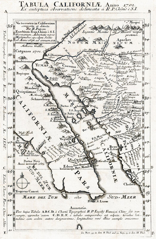
More Baja Maps added! 1702, 1788, 1912, 1926, 1927 & 1951
The amount of historic old maps of Baja California has just increased... See them in high detail at https://vivabaja.com/maps/ Just click on the map (at VivaBaja.com/maps) a second time to zoom in for detailed viewing!
Here see an overview, without the zoom in feature:
1702
1788

1912

1926

1927
1951
|
|
|
4x4abc
Ultra Nomad
Posts: 4202
Registered: 4-24-2009
Location: La Paz, BCS
Member Is Offline
Mood: happy - always
|
|
some very interesting details on these maps
I'll be lost for a few days
Harald Pietschmann
|
|
|
David K
Honored Nomad
Posts: 64547
Registered: 8-30-2002
Location: San Diego County
Member Is Offline
Mood: Have Baja Fever
|
|
It's like an Easter Egg hunt... you never know what you'll find until you look closely!
|
|
|
Lance S.
Nomad
Posts: 163
Registered: 2-16-2021
Member Is Offline
|
|
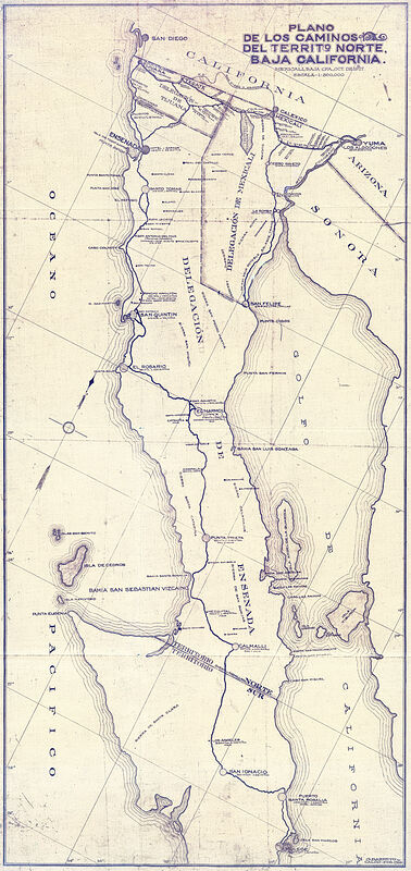
More great stuff. Not seeing the 1927 road plan one, curious where that comes from.
|
|
|
David K
Honored Nomad
Posts: 64547
Registered: 8-30-2002
Location: San Diego County
Member Is Offline
Mood: Have Baja Fever
|
|
Thank you for alerting me... I must have been sleepy!
It is now added with the other 1920s maps:
1921 Baja California Norte Districts (large)
1921 Baja California Norte Districts (medium)
1922 Baja California Map
1922 Baja California Geology Map
1923 & 1928 Baja California Geographical Maps
1926 Railroad Map (San Diego to Tijuana to Tecate to Mexicali to Yuma)
1927 Auto Club Maps (San Diego to the San Quintín area)
1927-1928 Road map, California to Mulegé (super zoom)
If the super-zoom version is too close, I have a medium zoom one as well. Posted above is the no zoom version.
|
|
|
bajaric
Senior Nomad
Posts: 612
Registered: 2-2-2015
Member Is Offline
|
|
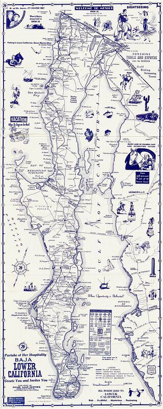
Love looking at these old maps! The 1927 shows a road from Chapala to Punta Prieta. Prior to then the main north-south routes in this area were
burro trails; either El Camino Real or the trail to the west described by Hale that passed by the "Leons" (Aqua Leon, Arroyo Loencito, Leon Grande,
etc.)
Walking south from Leon Grande in 1921 Hale described coming upon a graded "road to nowhere" that terminated abruptly in the desert. Upon following
it south they found it led to Punta Prieta. This was probably the early construction of the completed road shown on the 1927 map.
I believe that this road bridged one of the final gaps in the north-south route that were until then impassable to automobiles. Just 3 years later in
1930 AAA published their road map after driving the length of the peninsula.
|
|
|
4x4abc
Ultra Nomad
Posts: 4202
Registered: 4-24-2009
Location: La Paz, BCS
Member Is Offline
Mood: happy - always
|
|
everything checks out on the 1913 Mexicali/Laguna Salada map
except the hot springs
could not locate it
maybe it went cold or dried up

Harald Pietschmann
|
|
|
David K
Honored Nomad
Posts: 64547
Registered: 8-30-2002
Location: San Diego County
Member Is Offline
Mood: Have Baja Fever
|
|
Glad you guys are enjoying them!
Ric, did you see the photos at Agua Leon that Geoff recently posted in his trip report?
The 1930 AAA map and this 1927-28 one look a lot alike in many places... !?!
Harald, how do you spot a hot spring if no palms are growing, or ?? Being on the edge of the lake... like the ones in Puertecitos, Concepcion Bay,
Agua Verde, and El Sargento, I wonder if the body of water needs to be there? When Laguna Salada is dry, no hot water to pump up!
|
|
|
4x4abc
Ultra Nomad
Posts: 4202
Registered: 4-24-2009
Location: La Paz, BCS
Member Is Offline
Mood: happy - always
|
|
Quote: Originally posted by David K  |
Harald, how do you spot a hot spring if no palms are growing, or ?? Being on the edge of the lake... like the ones in Puertecitos, Concepcion Bay,
Agua Verde, and El Sargento, I wonder if the body of water needs to be there? When Laguna Salada is dry, no hot water to pump up!
|
Good question!
How do I know?
My own travel experience and user post in various groups
sometimes it takes me a couple of years to finally put the pin down in Google Earth
old maps are the most difficult as the locations are not very accurate
only approximate
I expect the hot springs (if they still exist) to be a bit a way from the Laguna Salada shore
just like Agua de las Mujeres
beautiful spot with palm trees on a hill side
the marker right of Las Mujeres is the Fumarole
the markers to the left are springs I have not checked on foot yet.

[Edited on 4-11-2023 by 4x4abc]
Harald Pietschmann
|
|
|
bajaric
Senior Nomad
Posts: 612
Registered: 2-2-2015
Member Is Offline
|
|
| Quote: Originally posted by David K | Glad you guys are enjoying them!
Ric, did you see the photos at Agua Leon that Geoff recently posted in his trip report?
|
I did see it on Geoff's trip report, also that he sighted a mountain lion in the general area. There must have been mountain lions there in the past
because so many places around there are named "Leon". Apparently, a few have managed to survive into the present day.
The road north from Punta Prieta to Chapala in 1927 was probably what we would call Old Hwy 1. It is a little west of paved Hwy 1. This is a picture
of a section of the old dirt road a little northwest of the BOLA junction. Looking west, Mesas el Leoncito in background.

|
|
|
Lance S.
Nomad
Posts: 163
Registered: 2-16-2021
Member Is Offline
|
|
From Homer Aschmann,
"The Automobile Club of Southern California and Governor Rodriguez, cooperating almost like sovereign powers, undertook to drive wheeled vehicles
south from San Quintin to connect with the road system of the southern Territory. In late 1926 an Auto Club group make it to Rosario, Note 6 and in
1927 a combined expedition of the Mexican military, including the Governor, and the Auto Club drove to San Ignacio, then over the Boleo Company's
roads to Santa Rosalia and Mulegé."
[Edited on 4-11-2023 by Lance S.]
|
|
|
David K
Honored Nomad
Posts: 64547
Registered: 8-30-2002
Location: San Diego County
Member Is Offline
Mood: Have Baja Fever
|
|
Perfect...
I have Homer's report on VivaBaja.com/maps, preserved by Fred Metcalf: https://vivabaja.com/wp-content/uploads/2021/12/History-of-t... along with his map showing the route of the main road to the tip, over the years:
https://vivabaja.com/wp-content/uploads/2021/12/Aschmann-197...
The old (pre-1973) route to La Paz is just west of Mex. #1, north of Punta Prieta. You can see it on satellite images. It wanders to the west from the
pavement south of El Crucero.
The road described by Hale in the 1920s is one I have wanted to see but a not so straightly engineered road is all that there is from Leon Grande
south to Punta Prieta. He may have written the book closer to the 1968 publishing date and the details could have been lost to memory after 40 years?
|
|
|
Lance S.
Nomad
Posts: 163
Registered: 2-16-2021
Member Is Offline
|
|
To push back the history of highway one a little further, the route they drove in 1927 effectively followed the San Ignacio-La Sierrita route
described in Itinererios y Derroteros. The route Nelson refered to as the western route.
That route in turn was based on Consags 1751 expedition route and part of Lincks 1766 expedition route.
Those routes in turn followed well traveled Cochimi routes.
[Edited on 4-11-2023 by Lance S.]
|
|
|
4x4abc
Ultra Nomad
Posts: 4202
Registered: 4-24-2009
Location: La Paz, BCS
Member Is Offline
Mood: happy - always
|
|
| Quote: Originally posted by Lance S. | To push back the history of highway one a little further, the route they drove in 1927 effectively followed the San Ignacio-La Sierrita route
described in Itinererios y Derroteros. The route Nelson refered to as the western route.
That route in turn was based on Consags 1751 expedition route and part of Lincks 1766 expedition route.
Those routes in turn followed well traveled Cochimi routes.
[Edited on 4-11-2023 by Lance S.] |
can you translate that to maps?
Harald Pietschmann
|
|
|
bajaric
Senior Nomad
Posts: 612
Registered: 2-2-2015
Member Is Offline
|
|
| Quote: Originally posted by David K | Perfect...
I have Homer's report on VivaBaja.com/maps, preserved by Fred Metcalf: https://vivabaja.com/wp-content/uploads/2021/12/History-of-t... along with his map showing the route of the main road to the tip, over the years:
https://vivabaja.com/wp-content/uploads/2021/12/Aschmann-197...
The old (pre-1973) route to La Paz is just west of Mex. #1, north of Punta Prieta. You can see it on satellite images. It wanders to the west from the
pavement south of El Crucero.
The road described by Hale in the 1920s is one I have wanted to see but a not so straightly engineered road is all that there is from Leon Grande
south to Punta Prieta. He may have written the book closer to the 1968 publishing date and the details could have been lost to memory after 40 years?
|
I think "the old (pre-1973) route to La Paz" or what i call "Old Hwy 1" was "the road to nowhere" described by Hale. If it had been the trail to Leon
Grande it would not have terminated abruptly in the desert. I would liken it to highway 5, before it was finished and it just stopped in the desert
north of Gonzaga.
Leon Grande, the spring and mining camp, was well-known enough to have been shown on maps. Beal's 1923 Geology map on vivabaja.com, probably the most
accurate, shows Leon Grande as about ten miles north of 29 degrees latitude and 27 miles due west of the coast at Bahia Blanca. This would put Leon
Grande about here: 29.043 -114.199, which makes sense, although that is only about 5 miles north of 29 latitude it is the right location in relation
to Aqua Leon. Or Leon Grande is somewhere north of there.
You can see an old trail that goes past that point and south until it hits Hwy 1. That was the probably the spot where Hale stumbled upon the end of
the road to nowhere, before the road was completed all the way to Chapala several years later and bypassed the trail that went past Leon Grande and
Agua Leon.
[Edited on 4-12-2023 by bajaric]
|
|
|
4x4abc
Ultra Nomad
Posts: 4202
Registered: 4-24-2009
Location: La Paz, BCS
Member Is Offline
Mood: happy - always
|
|
upper right corner of H11D26 and lower right corner of H11D16
[Edited on 4-12-2023 by 4x4abc]
Harald Pietschmann
|
|
|
Lance S.
Nomad
Posts: 163
Registered: 2-16-2021
Member Is Offline
|
|
Sorry, no maps. Would be cool to see all the routes overlain in different colors.
I believe this is Aguaje La Sierrita 29°51'59"N 115°03'36"W.
It is on the 1922 map. The goldbaum map takes the actual little mountain range called La Sierrita and places it where the aguaje should be. The
range is just south of the aguaje.
[Edited on 4-12-2023 by Lance S.]
|
|
|
Lance S.
Nomad
Posts: 163
Registered: 2-16-2021
Member Is Offline
|
|
Here's that article originally from 1913 that mentions the aguaje
https://www.academia.edu/27626752/G_Engerrand_s_New_Petrogly...
|
|
|
4x4abc
Ultra Nomad
Posts: 4202
Registered: 4-24-2009
Location: La Paz, BCS
Member Is Offline
Mood: happy - always
|
|
| Quote: Originally posted by Lance S. | Sorry, no maps. Would be cool to see all the routes overlain in different colors.
I believe this is Aguaje La Sierrita 29°51'59"N 115°03'36"W.
It is on the 1922 map. The goldbaum map takes the actual little mountain range called La Sierrita and places it where the aguaje should be. The
range is just south of the aguaje.
[Edited on 4-12-2023 by Lance S.] |
which 1922 map? Can't find it
Harald Pietschmann
|
|
|
David K
Honored Nomad
Posts: 64547
Registered: 8-30-2002
Location: San Diego County
Member Is Offline
Mood: Have Baja Fever
|
|
| Quote: Originally posted by 4x4abc | | Quote: Originally posted by Lance S. | Sorry, no maps. Would be cool to see all the routes overlain in different colors.
I believe this is Aguaje La Sierrita 29°51'59"N 115°03'36"W.
It is on the 1922 map. The goldbaum map takes the actual little mountain range called La Sierrita and places it where the aguaje should be. The
range is just south of the aguaje.
[Edited on 4-12-2023 by Lance S.] |
which 1922 map? Can't find it |
This one:
1922 Baja California Map
|
|
|
| Pages:
1
2
3 |


