| Pages:
1
..
5
6
7
8
9
10 |
mtgoat666
Select Nomad

Posts: 17415
Registered: 9-16-2006
Location: San Diego
Member Is Offline
Mood: Hot n spicy
|
|
Quote: Originally posted by pacificobob  | It never fails to amaze me how little locals know about the history of their area. Even current knowledge about areas 25kms from their place of birth.
Locally, here in South baja simple questions like , when did electricity come to the village?, where did your grandparents get water? Go unanswered or
with vague answers..... And minimal curiosity. |
If you ask me when electricity came to my town, i would not know…
Why are you asking locals inane questions about dates of infrastructure construction?
Woke!
“...ask not what your country can do for you – ask what you can do for your country.” “My fellow citizens of the world: ask not what America
will do for you, but what together we can do for the freedom of man.”
Prefered gender pronoun: the royal we
|
|
|
4x4abc
Ultra Nomad
Posts: 4200
Registered: 4-24-2009
Location: La Paz, BCS
Member Is Offline
Mood: happy - always
|
|
| Quote: Originally posted by mtgoat666 |
If you ask me when electricity came to my town, i would not know…
Why are you asking locals inane questions about dates of infrastructure construction?
|
remember your first car?
the year you got it?
good!
many places in Baja never had power (many still don't)
finally getting power is likely like getting your first car
but it could be that the Baja people don't really care much
they don't have money to buy anything that runs on power
except maybe light bulbs
for those the government had a free solar project in the 1990's for even the remotest places - you got a solar panel, a battery and one light bulb.
remember the days when in Bahia de los Angels the power went out at 10pm?
when the machinist was drunk it would not come on the next day
or when they were out of diesel (happened often) there was no power for weeks.
those days when the light stayed on past 10pm were sad days
it meant that someone had died
the corpse was stored in the walk in freezer at Guillermos and it needed to be kept cold over night
Harald Pietschmann
|
|
|
mtgoat666
Select Nomad
Posts: 17415
Registered: 9-16-2006
Location: San Diego
Member Is Offline
Mood: Hot n spicy
|
|
I have talked with quite a few locals who know their land well, the natural history, human history, etc.
it is sad you arm chair google earth travelers are writing off locals as ignorant bumpkins.
Woke!
“...ask not what your country can do for you – ask what you can do for your country.” “My fellow citizens of the world: ask not what America
will do for you, but what together we can do for the freedom of man.”
Prefered gender pronoun: the royal we
|
|
|
4x4abc
Ultra Nomad
Posts: 4200
Registered: 4-24-2009
Location: La Paz, BCS
Member Is Offline
Mood: happy - always
|
|
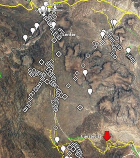
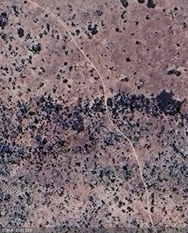
here is what i have so far
white blobs are water sources
the diamond signs are traces of trails
the yellow lines are trails wide enough for vehicles
the white lines are well established mining foot trails
many of them now used by MC groups
the red arrows are the high points of the trail
straight south from Leon Grande is very rugged - not likely
SE from Leon Grande is mountainous with deep canyons - not likely
only east has the terrain described in the report - very likely their path
the 2 high points kinda match
there are 2 sections of dead straight roads for the last part of the journey (long arrows)
the northernmost is likely the one as I understand they did not follow it
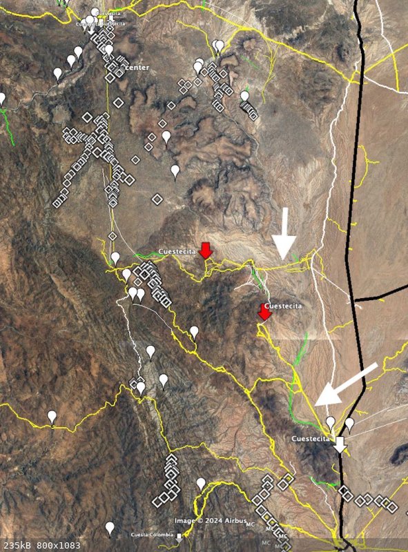
[Edited on 4-26-2024 by 4x4abc]
Harald Pietschmann
|
|
|
4x4abc
Ultra Nomad
Posts: 4200
Registered: 4-24-2009
Location: La Paz, BCS
Member Is Offline
Mood: happy - always
|
|
the northernmost straight road is not as dead straight as the Pemex trails from the 1950's - but very straight for Baja standards
Harald Pietschmann
|
|
|
David K
Honored Nomad
Posts: 64547
Registered: 8-30-2002
Location: San Diego County
Member Is Offline
Mood: Have Baja Fever
|
|
You have the old road to La Paz and the newer Baja 1000 road, both south from El Crucero, as white lines. These are auto roads, still. Just an fyi.
Otherwise, I love the work.
Can you add some kind of dashed line or other way to show us which lines you think Hale and friend hiked 100 years ago?
|
|
|
4x4abc
Ultra Nomad
Posts: 4200
Registered: 4-24-2009
Location: La Paz, BCS
Member Is Offline
Mood: happy - always
|
|
sorry - forgot to mention that
work in progress
the old Baja road is also in white
I have dash lines somewhere
Harald Pietschmann
|
|
|
Lance S.
Nomad
Posts: 163
Registered: 2-16-2021
Member Is Offline
|
|
That's amazing work Harald, you can see the trail that branches off and heads over the Mesa to Agua Leon. You can even make out where the Y junction
was. Thank you!
|
|
|
4x4abc
Ultra Nomad
Posts: 4200
Registered: 4-24-2009
Location: La Paz, BCS
Member Is Offline
Mood: happy - always
|
|
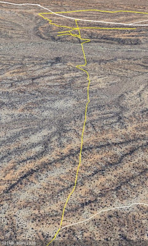
the straight line you see in my image is, as I believe, a signal line
there is a peak visible almost all the way from Leon Grande north
perfect direction for Codornices
29°16'39.77"N, 114°18'3.59"W

Harald Pietschmann
|
|
|
4x4abc
Ultra Nomad
Posts: 4200
Registered: 4-24-2009
Location: La Paz, BCS
Member Is Offline
Mood: happy - always
|
|
there is some new MC activity in the area
someone laying out a new trail
MCs are very active in that part of the desert
29° 7'56.88"N, 114°16'29.19"W
Harald Pietschmann
|
|
|
bajaric
Senior Nomad
Posts: 612
Registered: 2-2-2015
Member Is Offline
|
|
| Quote: Originally posted by 4x4abc | there is some new MC activity in the area
someone laying out a new trail
MCs are very active in that part of the desert
29° 7'56.88"N, 114°16'29.19"W
|
I was wondering when you were going to spot that trail. It is a single track originating at Agua Leon and going around and over the west side of Mesas
Leoncito then south towards Leon Grande. The trail matches Hale's route, could it be an old burro trail?
As for Leon Grande, I can't see any trace of it. I think it was never more than a couple of shacks next to a tiny spring. A possible explanation of
its inclusion on so many maps would be that Goldbaum, being a mining guy, would have known the area due to its proximity to Mina Columbia, a big gold
mine just to the south. When he drew his map there were some Germans that were involved in mining at BOLA who were building a road to a proposed mine
in the Leon Grande area. It's possible that Goldbaum knew of their activity at Leon Grande and put it on his map during the brief period when it was
occupied by the Germans. The mine was a bust, and the Germans all went home when the war ended. Subsequent map makers all copied Goldbaum, making
Leon Grande seem more substantial than it really was.
Old abandoned mining camps are usually very hard to see on Google Earth. After 100 years anything that was built from wood is long gone. Only
foundations or structures that were built from stone or adobe can still be seen. For example, even Las Flores, a substantial mill site with many
buildings can barely be seen on the satellite view. Everything is gone except one stone building. Same for Las Arrastras, Molino de Lacy, El
Crucero, La Milla, etc. These were all mining camps / mills built near a well or water source. The early Baja map makers always showed these camps on
their maps because they were inhabited places with water. Leon Grande, being a tiny camp, is understandably invisible.
[Edited on 4-28-2024 by bajaric]
|
|
|
David K
Honored Nomad
Posts: 64547
Registered: 8-30-2002
Location: San Diego County
Member Is Offline
Mood: Have Baja Fever
|
|
Thanks Ric... I guess that 'Long Walk to Mulegé' made a big deal of it as it was Goldbaum who advised the young WWI vets in Ensenada and provided
them with his map.
Howard Gulick, who traveled the peninsula by Willys-Jeep wagons, extensively from 1950 to 1970, never mentioned Leon Grande... which I though was odd.
Howard mapped the El Camino Real in 1954 and always provided history of the mines and villages. His original, large scale maps would be such a joy to
see. The Lower California Guidebook maps were abbreviations of the large maps Howard had made during his travels. I saw them at his friend (Andy
Anderson's) home... the one south of San Felipe I remember seeing as a kid and again when I popped in for a visit in 1976, when I was 18.
The maps are in the Gulick collection at UCSD... One day... mmmmmmmmmmm, one day!
|
|
|
4x4abc
Ultra Nomad
Posts: 4200
Registered: 4-24-2009
Location: La Paz, BCS
Member Is Offline
Mood: happy - always
|
|
I wrote this before -
Gulick was the first to make accurate Baja maps
he shows what's there
not "there should be a trail here somewhere"
Harald Pietschmann
|
|
|
mtgoat666
Select Nomad
Posts: 17415
Registered: 9-16-2006
Location: San Diego
Member Is Offline
Mood: Hot n spicy
|
|
What’s stopping you? You probably live 30 minutes from UCSD…
Woke!
“...ask not what your country can do for you – ask what you can do for your country.” “My fellow citizens of the world: ask not what America
will do for you, but what together we can do for the freedom of man.”
Prefered gender pronoun: the royal we
|
|
|
David K
Honored Nomad
Posts: 64547
Registered: 8-30-2002
Location: San Diego County
Member Is Offline
Mood: Have Baja Fever
|
|
Not that close... closer to an hour.
I guess I have not tried to see them is because of the shear size of the university, where to park, and not knowing protocol. Neal Johns (R.I.P) and I
were going to go see them at one time... then time won.
My step-son, Josh may be going there soon. His sister graduated from it a few years ago... I could ask them.
You are right to ask me, goat.
|
|
|
Lance S.
Nomad
Posts: 163
Registered: 2-16-2021
Member Is Offline
|
|
Some pretty cool stuff about the area, including info on water sources
Page 119
https://books.google.com/books?id=wM0QAAAAIAAJ&pg=PA120&...
|
|
|
4x4abc
Ultra Nomad
Posts: 4200
Registered: 4-24-2009
Location: La Paz, BCS
Member Is Offline
Mood: happy - always
|
|
| Quote: Originally posted by bajaric |
I was wondering when you were going to spot that trail. It is a single track originating at Agua Leon and going around and over the west side of Mesas
Leoncito then south towards Leon Grande. The trail matches Hale's route, could it be an old burro trail?
|
that MC trail is the hardest to follow of all MC trails I have found so far
some cow trails are easier
I guess, it sees little use
the frequently used MC trails are the easiest of all trails in Baja to spot on sat images
I love their elegance!
they weave through the landscape like no other
cow trails and MTB trails are more eradic, have harsher turns
MC trails have wide swings and gentle turns
by now I can tell just by looking at a trail/road who created it
animals, padres, ranchers, farmers, MC, MTB, hikers, private dozer, government dozer, Pemex, Boleo
Harald Pietschmann
|
|
|
4x4abc
Ultra Nomad
Posts: 4200
Registered: 4-24-2009
Location: La Paz, BCS
Member Is Offline
Mood: happy - always
|
|
there is another aspect that I like about the MC trails
they bring long forgotten trails back to life
Camino Real as well as mining trails.
One day the trail(s) betyween Agua Leon and Leon Grande will be back on the map
there is a new MC creation south of Leon Grande that I really like
looks like an old route from Punta Prieta to Leon Grande
Attachment: MC.kmz (19kB)
This file has been downloaded 5 times
Harald Pietschmann
|
|
|
mtgoat666
Select Nomad
Posts: 17415
Registered: 9-16-2006
Location: San Diego
Member Is Offline
Mood: Hot n spicy
|
|
| Quote: Originally posted by David K | Not that close... closer to an hour.
I guess I have not tried to see them is because of the shear size of the university, where to park, and not knowing protocol. Neal Johns (R.I.P) and I
were going to go see them at one time... then time won.
My step-son, Josh may be going there soon. His sister graduated from it a few years ago... I could ask them.
You are right to ask me, goat. |
Public university libraries are generally open for all. UCSD libraries are there for you.
Historical manuscripts/collections are often only viewable in certain rooms, due to being fragile. You normally just call or email to tell them what
you want to see, and book an appointment.
Parking on campus is easy, just pay the fee. The trolley and busses also serve campus.
The UCSD collection ae mostly listed on line, just call or email the listed contacts to ask how to access...
https://library.ucsd.edu/research-and-collections/special-co...
here is page to submit request for gullick maps
https://library.ucsd.edu/speccoll/findingaids/mss0091.html#a...
[Edited on 4-29-2024 by mtgoat666]
Woke!
“...ask not what your country can do for you – ask what you can do for your country.” “My fellow citizens of the world: ask not what America
will do for you, but what together we can do for the freedom of man.”
Prefered gender pronoun: the royal we
|
|
|
David K
Honored Nomad
Posts: 64547
Registered: 8-30-2002
Location: San Diego County
Member Is Offline
Mood: Have Baja Fever
|
|
Excellent find!
Text from that book from PC scanned to plain text:
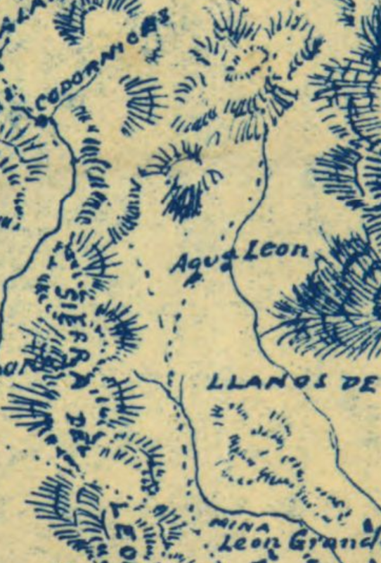
Mission Calamajué to La Vachata (Bachata): 70 kms. (Santa Maria and Rosarito quadrangles, pls. 58 and 60).
The trail to La Vachata goes southwestward through the narrow gorge of Arroyo Calamajué (8 kms.). Above the canyon there is a broad valley, and near
its upper end the trail divides, one branch going south via Yubay to Las Flores (San Borja quadrangle, pl. 61), and another southwestward to Los
Codornices and 1 lado (?), ranches which were not visited. Following the 1 tter (?) trail to the divide (elevation 2,000 feet), the trail descends the
gentle western slope to the arroyo below Los Codornices.
In this arroyo there is, near the trail, a large stone about ton feet high, against which have been leaned a number of logs, forming a shelter (20
kms.). Here a dim trail leads southeastward over a steep ridge, and down Arroyo Leon to Aqua Leon (28 kms.), where water may be obtained by digging at
various places in the arroyo.
From Pozo Salorio (1. 34A) to Leon Grande the trail is traversing the higher portions of the main range of the peninsula. Though the eastern slope is
precipitous, the topography of the western slope is fairly gentle, the valleys boing rather shallow, though steep-sided and the hill tops being broad,
gently undulating surfaces. this region, and the surface of the gr nitic terrain is only partially covered by a thin veneer of arkose sands, formed by
the decomposition of the granite in an arid climate.
Cirio (l. 343) and mezcal plants (pl. 151) are very numerous, but other vegetation is only rarely seen.
There are no ranches and travelers are seldom encountered.
Meloros (wandering, men who gather wild honey for a living) are the only humans that one is likely to meet.
Cirios with hollow trunks frequently contain bee hives, and both cirio
and mezcal furnish large quantities of strong nectar from which the bees
make honey. The region is nearly devoid of game and an occasional lizard
may be the only living creature seen in a day's ride.
Arroyo Leon may be followed all the way to La Vachata, but slight detours will load one to the Tinaja del Melero (33 kms.), where a small amount of
good water may be obtained by digging in the sand which fills the hollows in the rocks, and to the well of Leon Grande (42 kms.).
The latter is a well about 90 foot deep and has a windlass, cable, and a large iron bucket. As the well has been left uncovered for a long time,
lizard, rabbits, and snakes have been drowned in it, making the water undesirable but not absolutely unusable. exere (?) forced to drink it and carry
a supply with us and suffered no ill effects. A wagon road begins at the mine of Leon Grande (3 kms. from the well of that name), and follows the
arroyo to La Vachata, and ultimately to Calmallí (San Borja quadrangle, pl. 61).
This road is a part of a road which was intended to make wagon travel possible throughout the length or the peninsula. It has been built northward
from Calmallí, via Rosarito and San Andros (Rosarito quadrangle, pl. 60), and ends at Leon Grande. It is not likely that the northern extension of
this road will be built for many years, as there are few ranches in the region and the need for a road is not very great.
Punta Prieta (60 kms.), is a small settlement now occupied only by the families of two men who act as caretakers for the idle mill. (pl.343). Hills
were built here for working the ore from a number of mines in the vicinity.
|
|
|
| Pages:
1
..
5
6
7
8
9
10 |