| Pages:
1
2 |
AKgringo
Elite Nomad

Posts: 5870
Registered: 9-20-2014
Location: Anchorage, AK (no mas!)
Member Is Offline
Mood: Retireded
|
|
[Hurricane Norma] An interesting possible storm track from Windy.....
Their current forecast shows a system streaming across Southern Mexico to the Pacific where it turns into a tropical depression a few hundred miles
offshore. It then is forecast to head back north eastward toward the tip of Baja
I know a lot can change in the next week or so, but it is something to keep an eye on! In case you are not familiar with "Windy", hit the arrow on
the bottom left to put the forecast in motion.
https://www.windy.com/?19.872,-102.199,5
[Edited on 10-19-2023 by BajaNomad]
If you are not living on the edge, you are taking up too much space!
"Could do better if he tried!" Report card comments from most of my grade school teachers. Sadly, still true!
|
|
|
BooJumMan
Senior Nomad
Posts: 882
Registered: 8-11-2007
Location: San Diego
Member Is Offline
|
|
Been watching that for a few days myself. Each model run changes between both the GFS and ECMWF. I think Windy defaults to ECMWF? Anyway it was
showing a direct hit to Cabo just 3 days ago. The NHC is tracking it and showing the track to go up and hit Puerta Vallarta area. I trust the human
forecast model over the computer generated for things like this when the model guidance is all over the place.
In that pre-Google Earth and social media epoch, The Code was adhered to. It was based on a simple verity: if a locale had been transformational for
you, and you had put the hard yards in to get there and to learn it, to know it, why in god�s name would you broadcast the news, thus ruining the
future experience not only for yourself, but for future adventurers?
|
|
|
bkbend
Senior Nomad
Posts: 693
Registered: 11-27-2003
Location: central OR or central baja
Member Is Offline
|
|
In the windy settings you can switch between those two models, I'll do that and split the difference.
|
|
|
AKgringo
Elite Nomad
Posts: 5870
Registered: 9-20-2014
Location: Anchorage, AK (no mas!)
Member Is Offline
Mood: Retireded
|
|
Quote: Originally posted by bkbend  | | In the windy settings you can switch between those two models, I'll do that and split the difference. |
Thanks for the tip! there is quite a difference between yesterday's forecast, and between the different models.
If you are not living on the edge, you are taking up too much space!
"Could do better if he tried!" Report card comments from most of my grade school teachers. Sadly, still true!
|
|
|
mtgoat666
Select Nomad
Posts: 17473
Registered: 9-16-2006
Location: San Diego
Member Is Offline
Mood: Hot n spicy
|
|
| Quote: Originally posted by BooJumMan | | Been watching that for a few days myself. Each model run changes between both the GFS and ECMWF. I think Windy defaults to ECMWF? Anyway it was
showing a direct hit to Cabo just 3 days ago. The NHC is tracking it and showing the track to go up and hit Puerta Vallarta area. I trust the human
forecast model over the computer generated for things like this when the model guidance is all over the place. |
NHC is not identifying anything in their forecast similar to what you are seeing in windy. Windy just spits out computer model results with zero
interpretation by a human -- the predictions more than a few days out are usually worthless junk. Don't trust windy for forecasts a week plus -- read
the NHC posts for more accurate forecasts.
Woke!
“...ask not what your country can do for you – ask what you can do for your country.” “My fellow citizens of the world: ask not what America
will do for you, but what together we can do for the freedom of man.”
Prefered gender pronoun: the royal we
|
|
|
StuckSucks
Super Nomad
Posts: 2307
Registered: 10-17-2013
Member Is Offline
|
|
Tropical Weather Outlook
NWS National Hurricane Center Miami FL
500 AM PDT Mon Oct 16 2023
For the eastern North Pacific...east of 140 degrees west longitude:
1. South of Southwestern Mexico (EP90):
A broad area of low pressure located a few hundred miles offshore
of the southwestern coast of Mexico is producing showers and
thunderstorms and is gradually becoming better organized.
Environmental conditions are conducive for further development of
this system, and a tropical depression is likely to form within the
next day or two. This system is expected to move slowly westward
and then turn northwestward late in the week offshore of the coast
of southwestern Mexico.
* Formation chance through 48 hours...high...80 percent.
* Formation chance through 7 days...high...90 percent.
|
|
|
RFClark
Super Nomad
Posts: 2369
Registered: 8-27-2015
Member Is Offline
Mood: Looking forward to 2024
|
|
Today Windy has the yet to be storm doing a loop west of BCS then crossing the southern tip of BCS next Tuesday!
Stay tuned, the forecast changes every 6 hours. This is how the bad ones start!
|
|
|
StuckSucks
Super Nomad
Posts: 2307
Registered: 10-17-2013
Member Is Offline
|
|
Tropical Weather Outlook
NWS National Hurricane Center Miami FL
1100 AM PDT Tue Oct 17 2023
For the eastern North Pacific...east of 140 degrees west longitude:
1. South of Southwestern Mexico (EP90):
Satellite imagery indicates that showers and thunderstorms
associated with an area of low pressure located a few hundred miles
offshore of the southwestern coast of Mexico have become better
organized this morning. If these trends continue, advisories will
likely be initiated on this system as a tropical depression or
tropical storm later today. Additional information on this system,
including gale and storm warnings, can be found in High Seas
Forecasts issued by the National Weather Service.
* Formation chance through 48 hours...high...near 100 percent.
* Formation chance through 7 days...high...near 100 percent.
|
|
|
RFClark
Super Nomad
Posts: 2369
Registered: 8-27-2015
Member Is Offline
Mood: Looking forward to 2024
|
|
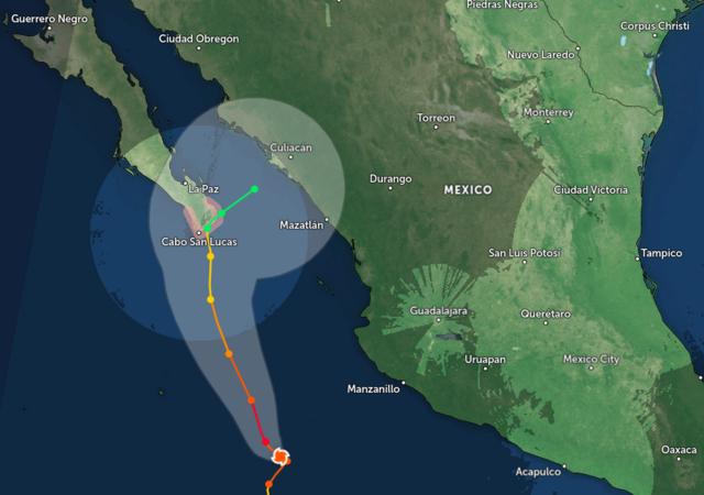
Norma is born!
The forecast thinks that the track will be to the right side of the envelope. Don’t count on it! 100kn winds around the center by landfall Sunday.

|
|
|
AKgringo
Elite Nomad
Posts: 5870
Registered: 9-20-2014
Location: Anchorage, AK (no mas!)
Member Is Offline
Mood: Retireded
|
|
What could add to the concern about the eventual track this storm takes, is that it appears to be moving slower than usual. What ever the wind and
rainfall winds up being, it might take many hours to pass!
If you are not living on the edge, you are taking up too much space!
"Could do better if he tried!" Report card comments from most of my grade school teachers. Sadly, still true!
|
|
|
mtgoat666
Select Nomad
Posts: 17473
Registered: 9-16-2006
Location: San Diego
Member Is Offline
Mood: Hot n spicy
|
|
Nhc saying the track forecast is a bit of a SWAG:
Norma is moving west-northwestward at an estimated motion of 285/9
kt. The system is expected to turn more northwestward at a slightly
slower forward speed during the next few days around the western
periphery of a mid-level ridge. Towards the end of the forecast
period as the system moves toward the Baja peninsula, there is a
notable divergence among the model suite. A stronger vortex, as
depicted in the GFS/CMC model, would be picked up by an approaching
trough from the northwest and move the system northeastward towards
the Baja peninsula. However, a weaker vortex would tend to meander
south of the peninsula and be missed by the approaching trough,
like the ECMWF/UKMET solutions. Since the NHC intensity forecast
is on the strong side of the guidance, the official track is closer
to the right side of the guidance envelope, more similar to the GFS
and HCCA models.
Woke!
“...ask not what your country can do for you – ask what you can do for your country.” “My fellow citizens of the world: ask not what America
will do for you, but what together we can do for the freedom of man.”
Prefered gender pronoun: the royal we
|
|
|
El Jefe
Super Nomad
Posts: 1027
Registered: 10-27-2003
Location: South East Cape
Member Is Offline
|
|
It looked all clear a week ago so the storm shutters came down. Hmm. We are here on the near east cape by La Fortuna and will let you all know how it
shakes out this weekend. Nice breeze out of the south right now and the skies are clouding over after a couple of hot sunny days.
No b-tchin\' in the Baja.
|
|
|
mtgoat666
Select Nomad
Posts: 17473
Registered: 9-16-2006
Location: San Diego
Member Is Offline
Mood: Hot n spicy
|
|
Hurricane Norma
DISCUSSION AND OUTLOOK
----------------------
At 900 PM MDT (0300 UTC), the center of Hurricane Norma was located
near latitude 16.4 North, longitude 108.0 West. Norma is moving
toward the north near 8 mph (13 km/h). A northward to
north-northwestward motion at a similar forward speed is anticipated
for the next couple of days. A slower motion is forecast is expected
by the weekend. On the forecast track, Norma could approach the
southern portion of Baja California on Saturday.

[Edited on 10-19-2023 by mtgoat666]
Woke!
“...ask not what your country can do for you – ask what you can do for your country.” “My fellow citizens of the world: ask not what America
will do for you, but what together we can do for the freedom of man.”
Prefered gender pronoun: the royal we
|
|
|
BajaNomad
Super Administrator
Posts: 4980
Registered: 8-1-2002
Location: San Diego, CA
Member Is Offline
Mood: INTP-A
|
|
https://www.windy.com/?22.452,-110.281,5
When I was young, I admired clever people. Now that I am old, I admire kind people.
– Rabbi Abraham Joshua Heschel
We know we must go back if we live, and we don`t know why.
– John Steinbeck, Log from the Sea of Cortez
Affordable Domain Name Registration/Management & cPanel Web Hosting:
https://www.regionalinternet.com |
|
|
pauldavidmena
Super Nomad
Posts: 1692
Registered: 5-23-2013
Location: Centerville, MA, USA
Member Is Offline
|
|
Zoom Earth shows Norma hitting Cabo as a Category 1 hurricane last Saturday night.
|
|
|
StuckSucks
Super Nomad
Posts: 2307
Registered: 10-17-2013
Member Is Offline
|
|

|
|
|
RFClark
Super Nomad
Posts: 2369
Registered: 8-27-2015
Member Is Offline
Mood: Looking forward to 2024
|
|
000
WTPZ42 KNHC 191452
TCDEP2
Hurricane Norma Discussion Number 8
NWS National Hurricane Center Miami FL EP172023
900 AM MDT Thu Oct 19 2023
Norma has continued to show signs of strengthening this morning. The
15 to 20 n-mi-wide eye of the hurricane is surrounded by a thick
ring of convective cloud tops colder than -70 to -75C. The initial
intensity is raised to 115 kt based on consensus T6.0/115 kt
subjective Dvorak classifications from TAFB and SAB. The Air Force
Hurricane Hunters are scheduled to investigate Norma later today.
The eye of Norma has deviated right of track during the past 6-12 h,
and the longer-term motion is nearly due north (360/6 kt). The
track forecast remains challenging. Even in the near term, there is
significant spread among the various models, likely related to
differences in the steering flow based on the vertical depth of the
cyclone. Given recent trends, the NHC forecast has been adjusted to
the right of the previous one through 60 h, bringing it just east of
the multi-model consensus aids and favoring the stronger GFS and
regional hurricane models. Thereafter, it remains unclear whether
Norma will turn northeastward and approach the west coast of
mainland Mexico, or stall and meander to the south of the Baja
California peninsula. The official forecast continues to show Norma
moving toward mainland Mexico beyond 60 h, albeit slower than some
of the stronger model guidance (GFS, HAFS) with a deeper vortex.
Once again, confidence is low and future track and/or speed
adjustments could be required.
Recent satellite images and model shear analyses suggest that
southerly shear is increasing over Norma and will continue to do
so over the next couple of days. Therefore, the hurricane is likely
near its peak intensity, although some small fluctuations cannot be
ruled out today. By Friday, weakening is expected as Norma likely
becomes more tilted by the shear and moves into a drier and more
stable environment. Still, Norma could be at or near hurricane
strength when it makes its closest approach to the southern tip of
Baja California, where a Hurricane Watch is in effect. Beyond 72 h,
the intensity forecast is more uncertain and highly dependent on
Norma's track, structure, and the extent (if any) of land
interaction with the Baja peninsula. If Norma moves faster than
forecast, it could reach the west coast of mainland Mexico as a
stronger storm. Given the track uncertainty described above,
interests there are encouraged to closely monitor forecast updates.
|
|
|
RFClark
Super Nomad
Posts: 2369
Registered: 8-27-2015
Member Is Offline
Mood: Looking forward to 2024
|
|
Norma on automated Navy (US) site 30 min updates
https://www.nrlmry.navy.mil/tc-bin/tc_home2.cgi?AGE=Latest&a... IR=/SATPRODUCTS/TC/tc23/EPAC/17E.NORMA/vapor/modis/1km&TYPE=ssmi&PROD=gif IR=/SATPRODUCTS/TC/tc23/EPAC/17E.NORMA/vapor/modis/1km&TYPE=ssmi&PROD=gif

[Edited on 10-19-2023 by RFClark]
|
|
|
AKgringo
Elite Nomad
Posts: 5870
Registered: 9-20-2014
Location: Anchorage, AK (no mas!)
Member Is Offline
Mood: Retireded
|
|
Norma seems confused!
If you are not living on the edge, you are taking up too much space!
"Could do better if he tried!" Report card comments from most of my grade school teachers. Sadly, still true!
|
|
|
bkbend
Senior Nomad
Posts: 693
Registered: 11-27-2003
Location: central OR or central baja
Member Is Offline
|
|
The models seem to be drifting a little more to the right except for a few outliers. I wouldn't want to have a ferry trip scheduled out of La Paz this
weekend.
|
|
|
BajaNomad
|
Threads Merged
10-19-2023 at 04:15 PM |
| Pages:
1
2 |


